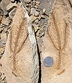
Araucaria (?) from Mesa Verde Group, Book Cliffs (eastern, Utah). Maybe from the Nelsen Formation (Upper Cretaceous) - DMNS has similar finds but from differently locality that is Nelsen formation. Possibly also in the Sego Sandstone (Upper Cretaceous). GPS: U02. See Geologic Map of Westwater 30' x 60' Quadrangle, Grand & Uintah Counties, UT & Garfield and Mesa Counties, CO (I-1765.pdf)
|

Images of the area where the Araucaria (?) were found. Location was approx 5-8 meters above the dirt road (lower right) and across the stream bed on the other side of road.
|

Images of the area where the Araucaria (?) were found. Location was approx 5-8 meters above the dirt road and across the stream bed on the other side of road.
|

View look southward back towards Mancos Shale of Book Cliffs.
|

Ripples in the sand. This was found approx. 100 meters above the fossil plant bench.
|

Appears to be cracks in sedimentary structure which were later filled in with silicates. About 80 meters above main fossil bench at GPS: "U02".
|

Appears to be cracks in sedimentary structure which were later filled in with silicates. About 80 meters above main fossil bench at GPS: "U02".
|

Appears to be cracks in sedimentary structure which were later filled in with silicates. About 80 meters above main fossil bench at GPS: "U02".
|

Appears to be cracks in sedimentary structure which were later filled in with silicates. About 80 meters above main fossil bench at GPS: "U02".
|

Appears to be cracks in sedimentary structure which were later filled in with silicates. About 80 meters above main fossil bench at GPS: "U02".
|

Palm fronds. Approx 5 meters above GPS: "U02"
|

Araucaria (?) from Mesa Verde Group, Book Cliffs (eastern, Utah). Maybe from the Nelsen Formation (Upper Cretaceous) - DMNS has similar finds but from differently locality that is Nelsen formation. Possibly also in the Sego Sandstone (Upper Cretaceous). About 5 meters above GPS: U02.
|

Araucaria (?) from Mesa Verde Group, Book Cliffs (eastern, Utah). Maybe from the Nelsen Formation (Upper Cretaceous) - DMNS has similar finds but from differently locality that is Nelsen formation. Possibly also in the Sego Sandstone (Upper Cretaceous). Approx 5 meters above GPS: "U02"
|

Araucaria (?) Approx 5 meters above GPS: "U02"
|

Araucaria (?) Approx 5 meters above GPS: "U02"
|

Araucaria (?) Approx 5 meters above GPS: "U02"
|

Araucaria (?) Approx 5 meters above GPS: "U02"
|

Araucaria (?) Approx 5 meters above GPS: "U02"
|

Araucaria (?) Approx 5 meters above GPS: "U02"
|

Araucaria (?) Approx 5 meters above GPS: "U02"
|

Palm fronds. Approx 5 meters above GPS: "U02"
|

Palm fronds. Approx 5 meters above GPS: "U02"
|

Basal portion of palm frond. Approx 5 meters above GPS: "U02"
|

Unident leaf. Approx 5 meters above GPS: "U02"
|

Unident leaf. Approx 5 meters above GPS: "U02"
|

Unident. Approx 5 meters above GPS: "U02".
|

Palm fronds. Approx 5 meters above GPS: "U02".
|

Palm fronds. Approx 5 meters above GPS: "U02".
|

Palm fronds. Approx 5 meters above GPS: "U02".
|

Chunk of dark black shale/coal. Approx 25 meters above GPS: "U02".
|

Thin slices of sandstone for painting. Appears to be cracks in sedimentary structure which were later filled in with silicates. About 5 meters above GPS: "U02".
|

Unident. About 5 meters above GPS: "U02".
|

Araucaria (?). About 5 meters above GPS: "U02".
|

Araucaria (?). About 5 meters above GPS: "U02".
|

Araucaria (?) & unident. About 5 meters above GPS: "U02".
|

Araucaria (?) About 5 meters above GPS: "U02".
|

Araucaria (?) About 5 meters above GPS: "U02".
|

Araucaria (?) About 5 meters above GPS: "U02".
|

Basal portion of palm frond. About 5 meters above GPS: "U02".
|

Araucaria (?) About 5 meters above GPS: "U02".
|

Unident. leaf. About 5 meters above GPS: "U02".
|

Unident. About 5 meters above GPS: "U02".
|

Palm frond. About 5 meters above GPS: "U02".
|

Palm frond. About 5 meters above GPS: "U02".
|

Map showing route to GPS waypoint "U02" - N39*18.030'; W109*17.859'; Elev 5323'. Heading west on I-70, just past rest area. North on road leading to old highway (Hwy-6). the back east to dirt 2nd dirt road heading north. Follow signs to Middle Canyon road. Go past private ranch with no trespassing signs (you will find many petroglyphs here) and proceed 1-2 miles on dirt road past ranch.
|