
DANIEL'S
PARK - STOP #1
8/10/2002,
10:15 am
| Daniel's
Park is located south of Denver & Highlands Ranch, Colorado.
From this location we could see a great panoramic from the south-southeast
to the west (see below). See the footnotes to the picture for an
explanation of the geology. |
GPS
Coordinates:
N 39o
28.343'
W 104o
55.370'
Elev: 6590 ft
PANORAMIC
(actual full-color view - scroll right
to see all)
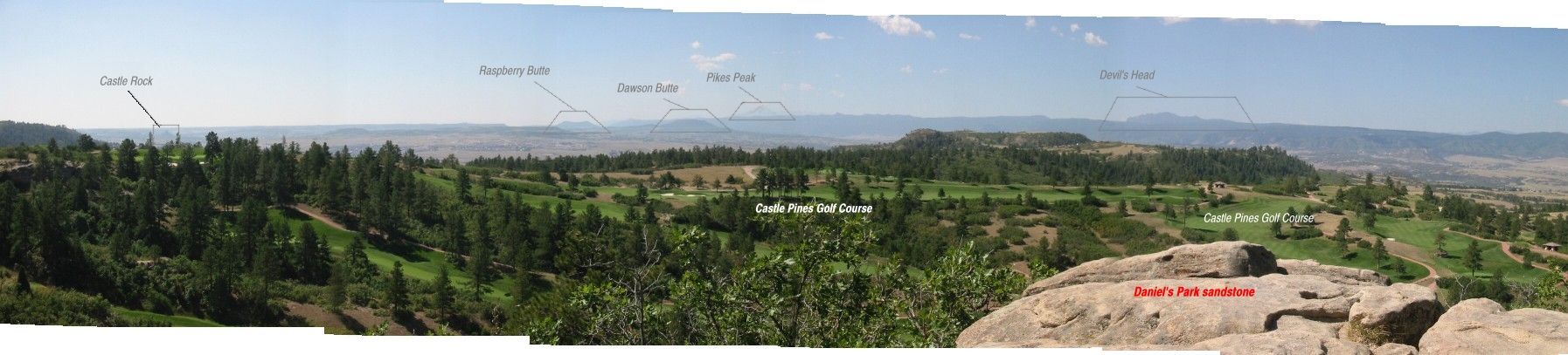
-
The buttes seen
along the horizon tell a story of the ancient landscape.
-
The sandstone
in the foreground at far right of image (scroll right) were the vantage
point for this picture. They contain clues of paleocurrent flow direction
(see further down this page).
-
Castle Pines golf
course, home of the PGA International tournament can be seen in the foreground.

SCHEMATIC
VIEW
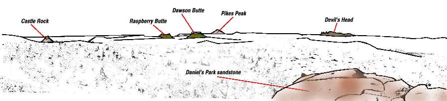
-
This is a schematic
view of the Daniel's Park overlook that is more representative of "paper"
field book.
-
This view shows
the valley that resulted from the Plum Creek drainage. The remaining
buttes withstood erosional forces because of their "caps" of rhyolite (and
some sandstone & granite).
-
Flood of 1965
resulted in Denver building Chatfield reservoir dam to protect against
future floods.
-
Image created
by tracing landscape with solid black line, then using "bucket fill" feature
to change the color details to white. Some color added afterwards
to accent geological features.
VIEW OF
LANDSCAPE WITH ANCIENT LAVA FLOW
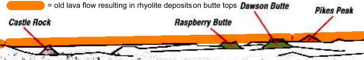
-
Volcanic flow
from an extinct volcano near Mt. Princeton flowed downward to the east.
At this time the area shown in the Daniel's Park overlook was flat.
The ORANGE line shows the lava flow that once existed. It is important
to note that for this lava flow to occur and a level line, the plum creek
drainage and rift valley further west could not have existed.
-
Over time, the
forces of erosion (likely from the Plum Creek drainage) eroded away much
of the landscape.
-
However, some
buttes here remained because the formations underneath the rhyolite were
compacted and held in place while other eroded away.
-
Of particular
interest is Castle Rock because it does not have a rhyolite cap on top
of the butte. Instead, it is composed of very large rhyolite blocks
in smaller granite cobbles and sandstone. This seems to indicate
that a massive flood occurred which moved these large rhyolite blocks downstream
where they were deposited in the other granite and sand. There are
close-up images of the castle rock conglomorate which tops the Castle Rock
butte. See the field trip page titled Castle
Rock.
-
Some buttes closer
to the town of Castle Rock were mined long ago for their rhyolite.
This was used as building material for some of the old buildings in downtown
Denver.
SANDSTONE
AT DANIEL'S PARK
This coarse
sandstone, or conglomorate, tops Daniel's park and provided the vantage
point for the pictures above. It contains of quartz, feldspar, mica,
etc. Feldspar contains lots of potassium and is sometimes referred
to as "K-spar" by geologists. Sometimes a rare Amazonite can be found
in this sandstone. Amazonite is a bright blue/green color and is
much sought after by gemologists.
To determine
the "provinance" (or origin) of the sandstone, we looked for clues.
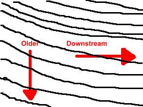
It is a fluvial (river deposited sandstone) formation. Trough crossbeds
can be found in the sandstone. To determine age, the lower trough
crossbeds are the older. Looking down on the crossbeds, we found
the typical "smile" patterns present. To determine the direction
of geocurrent flow, we combined the knowledge of lower is older and "smile"
direction. At the time of these deposits, the river was flowing nearly
due north (about 350 deg).
Simple reminder
for "smiles" and geocurrent direction:
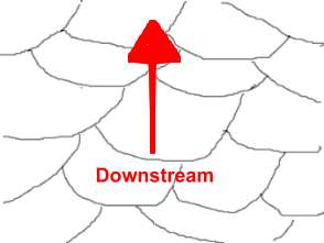
 | If you see a smile,
you are looking downstream in the ancient riverbed. (In a
river, it makes you smile to go downstream.) |
| If you see a frown,
you are looking upstream. (It makes you frown to go
upstream.) |
This sandstone
is part of the D2 formation and is 55 million years old.
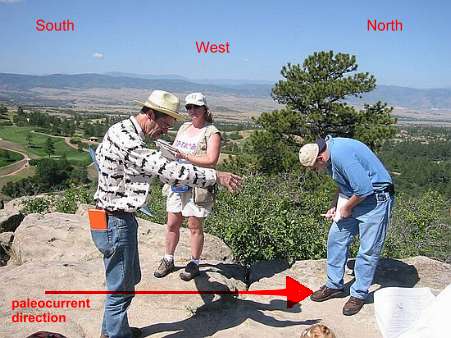
Bob Raynolds
describing trough crossbeds and direction of paleocurrent flow
Schematic
example showing "smiles" in trough crossbeds.
Schematic
example showing trough crossbeds (looking west).
A "rose" diagram
can be used to plot the polar coordinates and counts of each observation.
These are useful in understand general current flow at a given time and
location. Although we didn't take many samples of the paleocurrent
direction, a rose diagram of this area would like look something like this.
This indicates that at this location and time (55 mya), the paleocurrent
was flowing almost directly NORTH. Based on more data and research,
one would come to the known conclusion that the water flowed out of the
mountains and followed the Rockies north. Then, it slowly began curving
eastward before curving south and heading for the Gulf of Mexico.
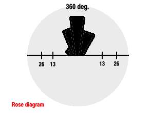
Rose diagram
showing expected paleocurrent at Daniel's Park sandstone.
Developed by Steve Wagner, Denver Museum of Nature & Science Volunteer
Hosting donated by Wagner Database Solutions, Inc. |
|