Castle Rock Fossil Rainforest
THE MAKING OF A FOSSIL
RAINFOREST
 Imagine
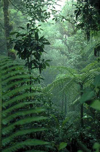
the floor of one of today's tropical rainforests. It is covered with
an uncountable number of leaves, branches and seeds. Plant material
is falling every day and covering up previous material. This continues
until the rainforest floor is a soft, spongy deposit of leaves. Most
of the plant matter decomposes, never to be seen again. However,
under certain circumstances, like occasional heavy rains and flooding,
water moves large quantities of sand and mud around the rainforest.
If this does not occur, it unlikely that fossil leaves would be preserved
from a rainforest environment.
With this in mind, what possible
sources of mud deposits might have contributed to Castle Rock's fossil
preservation? Let's look at three possibilities: rivers; lakes; and
mudslides. But, first, an understanding of the specific geologic
data found in our rock and leaf layers is required. At Castle Rock,
we find well-defined leaf layers (or leaf mat layers) with alternating
layers of mudstone (fine grained silt/mud/sand). There are three
clear sequences of leaf layer and mudstone layer. The mudstone layers
found in between leaf layers contain few fossil leaves. The occasional
leaves found in the mud layers are usually in a non-horizontal position.
They are found at angles to the horizontal plane and are often curved so
as not to fit even in an angled plane. We've even found several leaves
completely folded over at the primary vein resulting in a well-preserved
leaf on both side, with a layers of mudstone in between.
The mudstone layers are nearly pure
sediments of mud and sand, with occasional small tunnels in a vertical
position. All of these clues are important information in understanding
the ancient environment and determining the processes that took place to
fossilize Castle Rock's leaves. Now, with all of these clues, the
'detective' work begins.
The Lake Theory
Did these leaves fall into a lake?
Were they covered by silt and mud accumulating at the bottom of the lake?
This is unlikely for several reasons. If these leaves were falling
into a lake, the result would be that the leaves would be somewhat evenly
dispersed in the mud layers. Leaves and sediment would be mixed and
we would find fossil leaves throughout. However, the distinct layers
of leaf mat and nearly fossil-free mudstone indicate that that the Castle
Rock leaves were not preserved in the bottom of a lake. The mud appears
to have been deposited in relatively quick events. And, leaves at
the bottom of a lake would generally all have the same horizontal orientation,
or be folded over with little or no mud in between the folds. The
occasional leaves we find in the mudstone layers are at angles other than
the horizontal leaf mat layers. They are three-dimensional in that
they are wavy and when they are found folded over, they have sedimentary
deposition in between each half of the leaf.
The Mudslide Theory
The Castle Rock rainforest was near
the uplifting Rocky Mountains. Could it be that a mudslide from the
surrounding hills and mountains provided the preserving mud. This,
too, is unlikely. A mudslide typically contains a wide range of sediments
from fine silts and sands to pebbles and larger rocks. We don't find
this in our layers of mudstone. Also, a mudslide is a violent event
that would have ground up our leaves so as not to be unrecognizable.
The leaves in our mat and the mudstone layers are very well preserved.
And, a mudslide event would leave an uneven horizontal leaf mat layer.
Areas of the leaf mat would be depressed by the weight and force of the
mudslide.

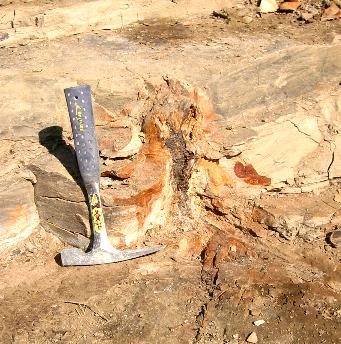
Tree trunk in vertical growing
position
in mudstone layers
|

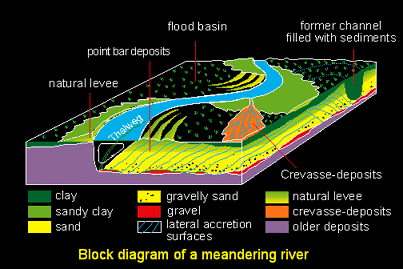
Block diagram of a meandering
river
(Utrecht University [1])
|
The River Theory
Was Castle Rock's rainforest near
a river? Were the mud deposits the result of occasional flooding?
This appears to be the most probably answer. During a flood, the
river breaches its banks and deposits sediment in the surrounding area.
The coarseness (fine, coarse, mixed) of the sediments can help us determine
what type of flood helped to preserve the fossil rainforest. Let's
look at the various flood scenarios that occur around a river. To
do this, we will refer to the concepts, structure and dynamics of a 'meandering
river'. If you are unfamiliar with these terms, please read the "Meandering
River" page first.
As you can see in the discussion
and stratigraphic sections of a meandering
river, there are numerous depositional environments surrounding the
river. The following discusses the most likely sources of deposition
and the likelihood that they correspond to our Castle Rock environment.
-
Crevasse-Splay: These are caused
by a break in the river's bank (or levee). Water gradually overflows
the levee and erodes it. Soon the water is rushing out of a breach
in the levee. Large amounts of sediment are deposited in a lobe shape
extending from the river. The resulting lobe of sediments often contain
a chaotic mix of sediments ranging from fine silts to pebbles and rocks.
The leaves would likely not have survived a crevasse-splay in the well-preserved
state we find in our quarries (if they survived at all). The more
violent nature of this event would likely have ground them up so as not
to be recognizable. However, the leaves in our mat layers and the
mudstone layers are very well preserved and don't contain the larger pebbles
and rocks. We can't completely rule out a crevasse-splay though.
There are many types of meandering rivers with a wide range of sediments
in their channels and banks. If the surrounding area was composed
of fine silts and sands, it's conceivable that a crevasse-splay event wouldn't
be violent enough to disturb the rainforest in the manner described above.
But, wouldn't it disturb the leaf mat more and churn more leaves up into
the mud layers?
-
Lateral Accretion Units: These
are deposits of sediment from the river channel resulting from the corkscrew
motion of the water as it hits the cut bank. The layers found in
these units are not horizontal, but slope downward from the point bar towards
the base of the cut bank. They contain a large percentage of sand
sediments. These 'lateral accretion units' on the slipoff-slope could
certainly be a source of 'some' fossilized leaves. However, one wouldn't
expect to find large layers of leaf mat in this very dynamic section of
the river. For these reasons, it's unlikely that this river environment
represents what we see at Castle Rock.
-
Overbank Deposits: In a
gradual rise in flood waters, the river may not break the levee as in a
Crevasse-Splay. It may simply overflow the bank. Such waters
usually contain much sediment in suspension, resulting in fine layers of
silt/sand deposition. This is precisely what we find in Castle Rock's
mudstone layers. This type of flood deposit would explain the undisturbed
leaf mat layers. These layers of large numbers of horizontal leaves
appear to be the rainforest floor. A gradual deposition of mud from
overbank deposition would likely not disturb the leaf mat much. As
the waters recede and the suspended sediments settle, some floating leaves
would be trapped in the mud/sand layers. It's also likely that these
leaves would not come to rest in horizontal positions. Again, this
is what we find in our mudstone layers.
The picture above of the tree
trunk growing in a horizontal position in the mudstone layers adds more
weight to the overbank deposit argument. This tree is actually a
medium sized trunk. We have found much larger trees (6 foot diameter)
and much smaller trees (2-3 inches). Would the smallest trees have
survived a crevasse-splay? Not likely. And, looking back at
the Lake Theory, we wouldn't expect to find trees growing in a lake bottom.
The same is true for the lateral accretion units because this is an ever-changing
environment not well-suited for trees.
But, what about those vertical tunnels
in the mudstone layers? It turns out that they are often filled with
sand. And, they are always found starting at the top of the mudstone
layer. Why is this? Picture an overbank flooding event with
large amounts of fine silts and sands. It's likely that there was
a considerable amount of standing water after the flood. These vertical
tunnels (or burrows) are fossil traces of previous worms and gastropods
that swam around in the shallow ponds left by the flood. The ponds
may have dried up or been filled in by subsequent floods. The fact
that the burrows are filled with sand is revealing. In subsequent
floods, in a fine sand and silt depositional environment, the sands would
be the heaviest and sink to the bottom first. Therefore, these burrows
would be primarily filled with sand. Again, this is exactly what
we find at Castle Rock.
Looking back at the crevasse-splay
theory, it's less likely that this event would leave large shallow ponds
in which burrowing creatures could survive. The same is true for
a mudslide event. Both of these events typically leave large deposits
with surfaces that dry and harden rather soon.
Another interesting observation is
that we very rarely find smaller plants growing from seeds in our leaf
mat layers. In one or two cases, we see a seed begin to branch out
horizontally in the leaf mat layer. However, the mudstone layers
do not have small roots growing, only remnants of past trees. We
find many seeds in the leaf mat layers, but they are intact and most have
never developed. What does this mean? It's likely that the
flood events that generated our mudstone layers occurred in rapid succession.
There was time for many leaves to fall to the forest floor, but we find
no evidence that seeds took hold.
It's interesting to note that
we don't know the size of the ancient Castle Rock rainforest. As
with modern rainforests, it was probably widespread. However, it
may have been preserved only in certain areas that benefited from the fossil
preserving mud deposits. In the future, other parts of this rainforest
may be discovered at other bends and flood plains near the ancient meandering
river.
A Rainforest Ending Flood
One thing is fairly certain in the
Castle Rock rainforest. A massive flood occurred sometime after our
leaf layers were deposited. It's possible that it even wiped out
our portion of the rainforest. Directly above our leaf layers, there
is something we call the massive layer. It's very thick and void
of leaves. It contains much coarser sediments and appears to be the
result of a more violent episode. We don't find tree trunks surviving
this event. This could have been a huge crevasse-splay or even a
mudslide. Much further above the massive layer, we find something
we've termed the 'wrong layer'. There are leaves in this layer, but
it's not a thick leaf mat layer like our others which appear to represent
the tropical rainforest floor. Could it be that these were deposited
from nearby rainforest areas that survived the massive flood event?
The further we get in the stratigraphic layers above our leaf mats, the
more we get into the unknown. Let's continue on with the story of
the fossilized rainforest as we observe in our in our leaf mat layers...
Continuing the Fossilization
Story
After the river's flooding provided
the necessary mud/sand deposits, the fossilization process may begin.
The sediments entomb the leaves in a protective layer which can slow or
stop their decomposition, providing the right environment to begin the
fossilization process. In subsequent flood events, the depositional
process continues to build layer upon layer of alternating plant material,
and sand and mud layers. The lower layers are gradually compressed
by the weight of the upper layers which begins to push out water and oxygen.
This too is required in the fossilization process because water and oxygen
will rapidly decompose leaves. Under the weight of many layers of
matter, the lowest layers begin hardening and turning to mudstone or sandstone.
Eventually, environmental factors such as a massive flood event, severe
climate changes, fires or falling volcanic ash cause the rainforest to
die. The area dries up and the rock layers continue to harden which
fossilizes the leaves over a period of millions of years.
The 'Return' of the Fossil Rainforest
Most fossils are never found.
They lay in rock layers thousands of feet below the earth's surface.
But, occasionally, geologic forces bring the fossils back to the surface.
This is often accomplished by geologic uplift from faults and mountain
building, combined with erosion which slowly reveals the lower layers containing
the fossils. Many times, the removal of the final layers to expose
the fossils is done by development efforts such as excavation of land for
new buildings or roads. The Castle Rock fossil rainforest was found
in such a place. Many years ago, a train track was built upon an
embankment. Excavation and development was going on all around the
area. Earlier developers may have had the fossil rainforest right at their
feet. They could have either missed it or didn't know what it was.
(Or, they could have kept it a secret for fear that their construction
would be halted. But, without knowing, well give them the benefit
of the doubt.) Alternatively, erosion of the embankment may have
slowly exposed the fossils. In 1994, Steve Wallace, a CDOT paleontologist,
was scouting the area in preparation for future road widening projects
when he discovered many large leaves. He contacted the Denver Museum
of Nature and Science which brings us to today's fossil excavation efforts
and the end of the very long story for the Castle Rock tropical rainforest
- a story spanning 64.1 million years. However, the ongoing efforts
of fossil recovery and identification have started a new chapter of scientific
discovery in learning about the ancient past of the planet on which we
live. To continue the story, please see "How
Fossils Leaves Are Recovered".
Sources:
1. Borehole
archives, Rhine-Meuse delta studies, Department of Physical Geography
(Utrecht University, Netherlands)
2. Principles of
Sedimentology, Gerald Friedman & John Sanders, 1978, John Wiley &
Sons.
3. "Meandering
River Channels", Colorado
Water Resources, Colorado State University
Paleocurrents.com
[Created
09/12/2002]
[Last Updated:
11/09/2002]
Developed by Steve Wagner, Denver Museum of Nature & Science Volunteer
Hosting donated by Wagner Database Solutions, Inc. |
 Imagine
the floor of one of today's tropical rainforests. It is covered with
an uncountable number of leaves, branches and seeds. Plant material
is falling every day and covering up previous material. This continues
until the rainforest floor is a soft, spongy deposit of leaves. Most
of the plant matter decomposes, never to be seen again. However,
under certain circumstances, like occasional heavy rains and flooding,
water moves large quantities of sand and mud around the rainforest.
If this does not occur, it unlikely that fossil leaves would be preserved
from a rainforest environment.

