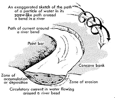
Figure 1 - The effect of a curved channel on water flow |
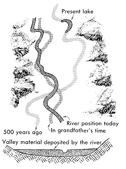
Movement of a meandering channel over time |
Rivers, and their sedimentary deposits, provide one of the important non-marine environments for fossilization. An basic understanding of river deposits can not only help one find fossils, but help to determine the paleoenvironment in which they lived. This page provides a background on a "meandering" river including its structure, dynamics and sedimentary deposit.Meandering streams spread out in low-relief valleys in the interiors of continents or in low-relief coastal plains. A characteristic of water flowing in a definite channel is that it tends to meander, not flow in a straight line. As meanders, or bows, in the river form, their presence only influences more meandering. The reason for this is that the main directional force of the river ends up colliding with the outer bank when it reaches a meander. The force of the water cuts into this outer bank (called the "cut bank") causing erosion and extending the meander outward (see Figure 1, below). At the same time, it generates a circular motion in the water which starts at the cut bank and rotates downward toward the bottom of the channel, then toward the inside bank and then back up to the surface. This causes sediments eroded from the cut bank to be deposited on the inside bank, known as the point bar. The result is that the channel is deeper on the outer cut bank than on the inner point bar. The material deposited on the point bar side forms a slope angling downward (deeper) from the point bar towards the cut bank. This is known as the slip-off slope.
The process of meandering may continue until one meander comes in contact with another meander. The river will then take the easiest, more direct, path which isolates the previous river channel. This creates a new body of water, called an oxbow lake, which is separate from the river's movement. Over time, a river may meander in many ways, leaving sedimentary deposits and oxbow lakes throughout a valley (see Figure 2, below).
|
Figure 1 - The effect of a curved channel on water flow |
Movement of a meandering channel over time |
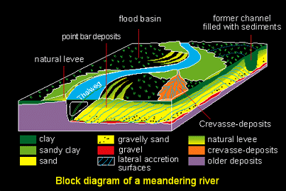
| Stream channel | The channel containing the flow of day-to-day water. |
| Flood Plain | Low, flat bottom areas that are covered by water only during a flood. |
| Point bar | Sand bar developing on the inside bank of the meander bend while the channel is migrating and the outside bank is eroded. Location of point-bar is clearly influenced by the meandering path. |
| Cut Bank | Outer bank of meander where force of water cuts both outward and downward. |
| Oxbow lake deposits | Meander loop bypassed by the river, because of a neck-cutoff, i.e. when both ends of the meander meet, or a chute-cutoff, i.e. reoccupation by the river of more direct course. Fined grained sediments generally fill the abandoned channel and form impermeable units (mud-plugs). |
| Overbank deposits | Sediments deposited by a river on a valley floor outside the stream channel. Such waters usually contain much sediment in suspension, resulting in fine layers of silt/sand deposition. |
| Avulsion | When a channel breaches its levee and takes a new course. If the avulsion fails, deposited material form crevasse-splay deposits. |
| Crevasse splay | When a channel temporarily floods over its bank depositing a lobe shape of sediments. If the event is a violent flood with mudflow, the deposit may consist of chaotic assemblages of course- and fine- grained sediments (gravel). |
| Alternate bars | longitudinal sand deposit in the course of the stream. Alternate bars migrate down the channel |
| Slip-off slope | Sedimentary slope from point bar of meander towards cut bank. Consists of layer upon layer of sediments, or lateral accretion units. |
In times of flooding, the river breaches its banks. It may temporarily cut through the outer levee and spill large quantities of water and sediments. This is known as a crevasse splay, which is typically in a lobe shape with a mixture of fine- and coarse-grained sediments (see Point Bar Sequence of Figure 3; and orange crevasse deposits of Figure 4). In a less violent flood, the level of the water may rise gradually and simply overflow its bank (overbank deposits) without actually breaching the levee. This also results in flooding of the flood plain, but the resulting sedimentary deposits will be fine-grained sheets of silt as opposed to the mixture of sediments in the crevasse splay.The stratigraphic column of an ancient meandering river is shown below in Figure 3.
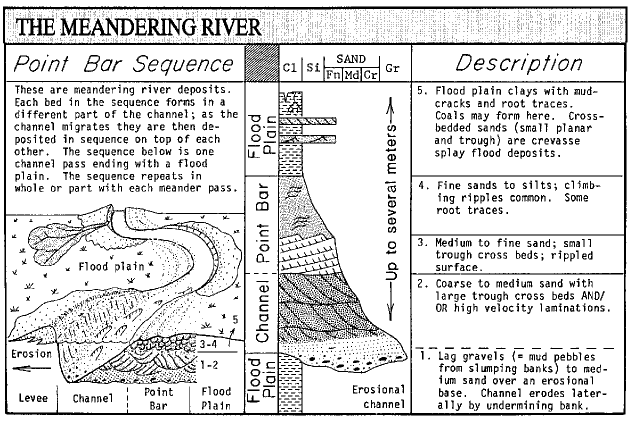
Figure 3 - The Meandering River
(Lynn S. Fichter [1])
See how these concepts are put to work in understanding the Castle Rock rainforest in "Making of a Fossil Rainforest".
1. "Meandering
River", diagram, Lynn S. Fichter, Organization
of Sedimentary Rock Site, Department of Geology/Environmental Science,
James Madison University Harrisonburg, Virginia (used with permission)
2. Borehole
archives, Rhine-Meuse delta studies, Department of Physical Geography
(Utrecht University, Netherlands)
3. "Meandering
River Channels", Colorado
Water Resources, Colorado State University
4. Leopold, Luna B. and Walter B.
Langbein. A Primer on Water. U.S. Geological Survey. U.S. Government Printing
Office: Washington D.C., 1960.
5. Ritter, Dale F., R. Craig Kochel,
and Jerry R. Miller. Process Geomorphology. Wm. C. Brown Publishers: Dubuque,
Iowa, 1995.
6. Principles of
Sedimentology, Gerald Friedman & John Sanders, 1978, John Wiley &
Sons.
Hosting donated by Wagner Database Solutions, Inc. |