Field School, Day 7 (7/12/03) - Paint
Mines in Calhan,
Colorado
 We
began Day #7 with a morning lecture by Bob Raynolds. He discussed the
multi-disciplined Denver Basin project and the fact that it's also important to
present-day issues facing the Front Range. A major part of Bob's work is
in researching the aquifers of the Denver Basin. The significant aquifers
hold ancient water and do not get replenished from surface water.
Therefore, they are limited resources and when they are gone, they're
gone. Due to accelerated development throughout the Denver Basin, and most
notably Highlands Ranch, the water level in the Arapahoe aquifer is falling at a
rate of 10 meters/year, or about 1" per day. This could be a serious
problem for communities who rely heavily (or solely) on aquifer water like many
areas south of Denver. The aquifers aren't like a big underground bucket
of water. The water permeates the rock. When wells are drilled into
the aquifer, water is easily removed - first from the most porous rock. As
water levels continue to fall, it will become harder and more expensive to
extract the water. This known fact will translate into higher water bills
for the dependent communities. Eventually, it will be too costly to
extract water from the aquifers and other sources such as pipelines or trucks
may be the cheaper alternative.
We
began Day #7 with a morning lecture by Bob Raynolds. He discussed the
multi-disciplined Denver Basin project and the fact that it's also important to
present-day issues facing the Front Range. A major part of Bob's work is
in researching the aquifers of the Denver Basin. The significant aquifers
hold ancient water and do not get replenished from surface water.
Therefore, they are limited resources and when they are gone, they're
gone. Due to accelerated development throughout the Denver Basin, and most
notably Highlands Ranch, the water level in the Arapahoe aquifer is falling at a
rate of 10 meters/year, or about 1" per day. This could be a serious
problem for communities who rely heavily (or solely) on aquifer water like many
areas south of Denver. The aquifers aren't like a big underground bucket
of water. The water permeates the rock. When wells are drilled into
the aquifer, water is easily removed - first from the most porous rock. As
water levels continue to fall, it will become harder and more expensive to
extract the water. This known fact will translate into higher water bills
for the dependent communities. Eventually, it will be too costly to
extract water from the aquifers and other sources such as pipelines or trucks
may be the cheaper alternative.
 We
traveled to Calhan to the beautiful paint mines. The history of the name
comes from the fact that Native Americans once used the colorful soils of the
area to make paint for their horses, faces and tools. The land was
recently purchased by the county (with funding assistance from others) and will
soon be a county park. The colorful soils of the surrounding region have
been mined for decades and used in bricks in buildings of downtown Denver and
Coors Field.
We
traveled to Calhan to the beautiful paint mines. The history of the name
comes from the fact that Native Americans once used the colorful soils of the
area to make paint for their horses, faces and tools. The land was
recently purchased by the county (with funding assistance from others) and will
soon be a county park. The colorful soils of the surrounding region have
been mined for decades and used in bricks in buildings of downtown Denver and
Coors Field.
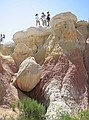
Geologically, the Calhan Paint Mines are a great place to see the D1/D2
interface of the Denver Basin. It's also an excellent historical record of
the paleosol. Generally, finding the paleosol in the Denver Basin is a
tough assignment. It's occasionally revealed in construction project like
the Castle Rock Outlet Stores. But, it's either paved over or vegetation
quickly hides it once again. In contrast, the paleosol at the Calhan Paint
Mines has been protected and preserved by the sandstone deposits of an ancient
river. The thick white sandstone of the ancient river provides a caprock
over the paleosol to limit erosion (see picture above). The important
sites at the paint mines also include: a conifer swamp below the paleosol of the
same age as the Castle Rock fossil rainforest; and two Eocene plant localities
above the paleosol.
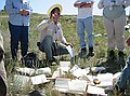 We
diagrammed the geologic features in two different locations in the paint
mines. During this effort, we discussed important features which should
always be in a geologic drawing such as: north indicator, height/width estimates
of drawn area; stratigraphic composition labels, paleocurrent flow directions,
GPS readings if possible, etc. After the first drawing, we all laid our
books on the ground for comparison (see left). Kirk Johnson and Bob
Raynolds pointed out differences and important features in the field drawings.
We
diagrammed the geologic features in two different locations in the paint
mines. During this effort, we discussed important features which should
always be in a geologic drawing such as: north indicator, height/width estimates
of drawn area; stratigraphic composition labels, paleocurrent flow directions,
GPS readings if possible, etc. After the first drawing, we all laid our
books on the ground for comparison (see left). Kirk Johnson and Bob
Raynolds pointed out differences and important features in the field drawings.
It's impossible to describe the geologic beauty of the area in words.
Please see the pictures from Day 7 (link below).